Info portal of Harrachov
Harrachov > Service > How to get here
How to get here
Geographical coordinates GPS
- Loc: 50°46´19.514"N, 15°25´53.087"E
Altitude
- 686 m above sea level
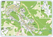
Map
![]() or
or ![]()

 THE NEAREST AIRPORT
THE NEAREST AIRPORT- Praha – Ruzyně
- the distance from Harrachov is 125 km
- www.csl.cz
Complete public transport timetables - www.idos.cz
SKIBUS
Skibus provides the transport from the train station to the center of Harrachov and up to Rýžoviště in winter season.
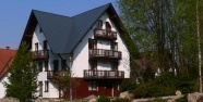
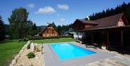
ACCOMMODATION - ON-LINE RESERVATION
Lastminute accommodation Harrachov
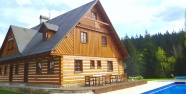
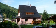
Pension Svatý Jan
450 CZK / person / day breakfast incl.
Apartmán Alice
350 CZK / person / day without board
Pension Schäfer
570 CZK / person / day breakfast incl.
Top Apartman Blue Cafe
395 CZK / person / day without board
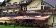
Hotel Centrum
750 CZK / person / day breakfast incl.
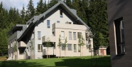
Resort Resident Harrachov
595 CZK / person / day breakfast incl.
Weather Harrrachov
 Mon 20.11.day 1°C / night -1°C
 Tue 21.11.day 5°C / night -1°C
 Wed 22.11.day 5°C / night 2°C
- Package Deals
- On-Line Reservation
- Activities in Harrachov
- Cycleways in Harrachov
- Harrachov Map
- When it’s raining
- Harrachov Card
Partneři:
- Jánské Lázně,
- Špindlerův Mlýn,
- Chaty a chalupy,
- Autodíly, náhradní díly,
- Levné lyže,
- Sportovní areál Harrachov,
- Reality na Floridě,
- Pension Harrachov,
- Classic Ski School,
- Pneu, hliníková kola,
- Itálie Bibione,
- Skiregion.cz,
- CDR-shop,
- Ubytování, Hotely, Penziony, Chaty, Chalupy,
- Chaty a chalupy k pronajmutí,
- Autopůjčovna Rostcar,